Beinn Eighe
| Munro Tops: |
- Ruadh-stac Mor
- Spidean Coire nan Clach
|
| Heights: |
|
| Map Reference: |
- R-sM: NG 952613
- SCnC: NG 967598
|
| Maps: |
- OS Sheets (1:50000): 19 and 25
- OS Sheet (1:25000): Sheet 8
- Harveys Superwalker: Torridon
|
| Our Ascents: |
|
Introduction
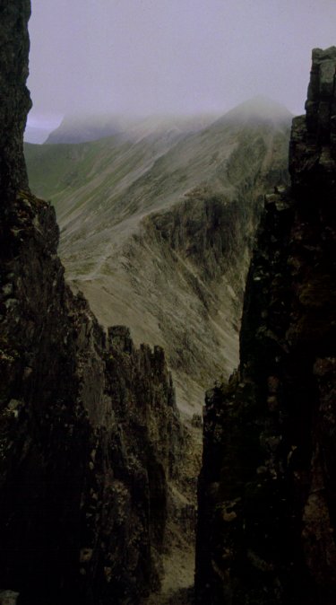
Beinn Eighe is largest mountain in the Torridon range - a complete
mountain range in itself. The complete range covers some 10 km and dominates
the north side of Glen Torridon. If arriving from Achnasheen in the east it is
the eastern tops that you see first - the quartz rock giving the appearance of
a snow-topped peak overlooking the small village of Kinlochewe. The narrow road
to Shieldaig follows the foot of the southern slopes until the dominating
cliffs of Liathach catch the eye at the head of Upper Loch Torridon.
The Western End
It had started as the fourth misty and wet day in succession at Gairloch
and we had really decided to pack up and go home. We got to Kinlochewe just
after 11:15 and found some patches of blue sky over the Beinn Eighe ridges. The
plan was revised and we drove hastily down the road towards Loch Torridon. By
12:00 we were walking - having thrown together a quick lunch and snacks.
 We ascended by the Coire an Lough
path - a well constructed and steep path as far as the corrie and easy to
follow in the higher stretches. The cloud did not clear the tops but the ridges
came and went although the Coulin Forest area on the far side of the glen was
clear. The last pull to the short southern ridge to Spidean Coire nan
Clach is up a dirty path on the grassy slopes and within two hours of
starting we wandered the few yards to the cairn on Stuc Coire an Lough.
We rested for a chocolate bar and apple watching the following party of five
men ascend to the ridge by the same path. Picking up our rucksacks we climbed
the final 400 ft through the mist on a steep and rough path to the trig point
on the first top. Ignoring this we continued north-east to the narrow summit
rock that is the higher summit at 993m; in mist it is important to realise that
the trig point is a false high point and not the recently promoted Munro
peak.
We ascended by the Coire an Lough
path - a well constructed and steep path as far as the corrie and easy to
follow in the higher stretches. The cloud did not clear the tops but the ridges
came and went although the Coulin Forest area on the far side of the glen was
clear. The last pull to the short southern ridge to Spidean Coire nan
Clach is up a dirty path on the grassy slopes and within two hours of
starting we wandered the few yards to the cairn on Stuc Coire an Lough.
We rested for a chocolate bar and apple watching the following party of five
men ascend to the ridge by the same path. Picking up our rucksacks we climbed
the final 400 ft through the mist on a steep and rough path to the trig point
on the first top. Ignoring this we continued north-east to the narrow summit
rock that is the higher summit at 993m; in mist it is important to realise that
the trig point is a false high point and not the recently promoted Munro
peak.
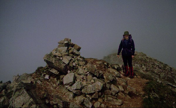
We were soon joined by the following party and it transpired that one of
them was completing his round of all Munros; Susan offered a kiss of
congratulation to the individual concerned and we joined in the whisky and
champagne celebrations. We were near the top of the clouds so blue sky and sun
kept breaking through as we sat perched on the rocks. However we only got
glimpses of the ridges we were on. In the hope of better ahead we tackled the
ridge eastwards - a mixture of shattered quartz and sandstone - as it swings
round the corrie to the north. On the climb to Coinneach Mhor the mist
thickened and we rejoined the following party to strike up the grassy slope to
the summit cairn. Here we reset the compass to drop down the north ridge - a
steep descent but a clear path to follow.
 We passed on the option of
continuing to the second (and higher) Munro summit of Ruadh Stac Mhor -
it was already past 4:00pm - and dropped into Coire Mhic Fearchair.
Keeping left of the scree on a steep and loose path we passed some small
lochans before reaching the loch in the corrie floor. The mist was thick and we
soon missed the path - although we did pass several shadowy figures on their
way up the hill (they also only realised the potential of the day at a late
hour). The corrie was thick with mist - you could only see a few yards and
there was no hope of viewing the large buttress cliffs on the far side.
Crossing the stream at the lip - above the cascade falls - we picked up the
reconstructed path sections at the start of the long walk out. We passed the
work gang who had been repairing the upper sections for the National Trust for
Scotland all week and had not seen a thing as the mist had never cleared.
We passed on the option of
continuing to the second (and higher) Munro summit of Ruadh Stac Mhor -
it was already past 4:00pm - and dropped into Coire Mhic Fearchair.
Keeping left of the scree on a steep and loose path we passed some small
lochans before reaching the loch in the corrie floor. The mist was thick and we
soon missed the path - although we did pass several shadowy figures on their
way up the hill (they also only realised the potential of the day at a late
hour). The corrie was thick with mist - you could only see a few yards and
there was no hope of viewing the large buttress cliffs on the far side.
Crossing the stream at the lip - above the cascade falls - we picked up the
reconstructed path sections at the start of the long walk out. We passed the
work gang who had been repairing the upper sections for the National Trust for
Scotland all week and had not seen a thing as the mist had never cleared.
The walk round to the road is long and rough - the newly restored
sections make for faster progress but the cobbles and boulders are much harder
on the feet. We did not leave the mist until we were well down and turned the
watershed between Beinn Eighe and Liathach. The path improves as you near the
road and the western car park. It was 7:00pm by the time we reached the road
and were fortunate to get a lift the short distance along the road - picking up
the lead walker from the party that had followed us all day (he had been
despatched to retrieve their vehicle).
We returned to Kinlochewe and re-pitched the tent at Taagan for the
night before retiring to the pub for drinks and supper. From the brink of
abandoning the week we had traverse this impressive ridge - and the forecast
for the next two days was better.
The Eastern Ridge
We were camping at Big Sands in Gairloch and we awoke to low mist and
rain so we were in no rush to get up and out. We toured into Torridon to find
that the main tops were free of mist so we opted to climb onto the eastern
ridge of Beinn Eighe.
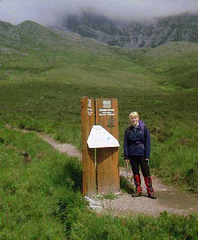
We parked the car at Cairn Shiel and started the initial approach
at 12:00 following a wet and boggy path as it climbed slightly on the north
side of Allt a Chuirn. At the 250m contour the path passes through a
gate in the deer fence that protects the lower slopes from excessive grazing to
cross a tributary to the stream. Both branches of the stream have cut deeply
into the hillside and it is a steep and rough scramble to cross to the far
bank. After all the recent rain there was a fair bit of water flowing - the
crossings would be troublesome when in full spate. The water was crystal clear
and fresh tasting thanks to the quartz terrain and limited peat cover.
 The path climbs a sharp crest
between the two tributaries - through a few trees - to a rough boulder field
that extends to the foot of the crag marking the end of Creag Dubh
eastern ridge. The path follows the northern stream before taking an obvious
left to right rising traverse across a low buttress, then passing to the right
of the crag. Beyond it strikes directly up the scree slope in a series of
zig-zags to gain the ridge next to a cairn sitting at the foot of the ridge to
the main summits - an almost aerial viewpoint over the valley below. The route
continues in a direct ascent of the ridge - it is narrow and steep but offers
no difficulty - to gain the first summit on the main ridge. Here we stopped for
lunch watching the cloud skimming briskly over the tops and as the cloud level
lifted slightly the entire ridge of Beinn Eighe was revealed. To the north
Slioch and An Teallach were clear.
The path climbs a sharp crest
between the two tributaries - through a few trees - to a rough boulder field
that extends to the foot of the crag marking the end of Creag Dubh
eastern ridge. The path follows the northern stream before taking an obvious
left to right rising traverse across a low buttress, then passing to the right
of the crag. Beyond it strikes directly up the scree slope in a series of
zig-zags to gain the ridge next to a cairn sitting at the foot of the ridge to
the main summits - an almost aerial viewpoint over the valley below. The route
continues in a direct ascent of the ridge - it is narrow and steep but offers
no difficulty - to gain the first summit on the main ridge. Here we stopped for
lunch watching the cloud skimming briskly over the tops and as the cloud level
lifted slightly the entire ridge of Beinn Eighe was revealed. To the north
Slioch and An Teallach were clear.
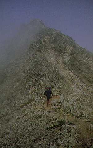
We walked along the easy ridge to the start of Black Carls Pinnacles -
the most difficult section on the entire ridge. Andrew had complained
throughout most of the ascent and so opted to return along the ridge and back
down as soon as the suggestion was made. Simon and Susan carried on over the
pinnacles to the summit of Sgurr nan Fhir Duibhe. Scrambling of varying
difficulty can be readily by-passed by paths on the south side. Care is needed
in climbing as the quartzite is heavily shattered and loose in its sockets -
any dislodged rocks bounce and roll a long way down into the corrie below.
By the time we reached the summit the tops were starting to cloud over
and we decided that a second walk up here in mist within the same season was
not worth the effort, so we retraced our steps to catch up with the other two.
The descent is steep and unrelenting on the hard rock and scree - it was a real
relief to reach the flatter and softer ground despite the wet and boggy nature
of the peat.
We got back to the car at 6:00pm, rinsed the boots off (quickly -
because of the midges) in the river and piled into the car to drive the short
distance to Kinlochewe for a drink. Here we checked the map to establish if
Andrew had crossed the 3000ft contour even though he did not cross the
pinnacles - he had. It was the only 3000ft expedition of the two week holiday
despite our original intention to explore the Torridon district. The summer of
1998 was a wet and frustrating year for mountain baggers!
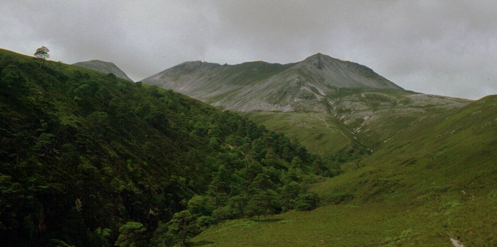
Coire Mhic Fearchair
One of the most impressive sights in the Western Highlands is the
Tripple Buttress that forms the backwall to Coire Mhic Fearchair on the
northern side of the mountain. It is a popular walk starting from the car park
at the Allt a Choire Dhuibh Mhoir and following a well made path between
Liathach and Beinn Eighe. The path rises to the height of the pass at just
under 400m and divides, the right hand branch turning the west and north flank
of Sail Mhor to gain the lip of the corrie. The walk climbs to a fraction under
600m; the stream from the loch in the corrie basin shoots over the rocks in a
series of running cascades and waterfalls.
Once in the corrie itself the scenery is dominated by the hugh 1000ft
cliffs towering above the water - the extensive cliffs under Sail Mhor
on the right, and the unmistakeable Triple Buttress under Coinneach Mhor
at the head of the loch.
From here you can strike up to the ridge if you so wish. The obvious
route to the col under Ruadh-stac Mor is further than it looks - passing a
series of lochans before turning into a steep and dirty climb - and many guides
suggest a striking east up the hillside on a direct assault to the top. For the
less ambitious you can circle the loch - the eastern side is much easier to
traverse than the side under the cliffs. The walk is some 6.5km from the road
to the corrie and although the path has been reconstructed along much of its
length, the cobbles are quite hard on the feet. This is however an excellant
walk for those not wishing to tackle the ridges.
References
- The Big Walks includes a full traverse of the ridge from the
Allt a Choire Dhuibh Mhoir car park in the west, climbing to
Ruadh-stac Mor and completing the traverse to Kinlochewe.
- Ralph Storer devotes two routes to this mountain in the 100 Best
Routes on Scottish Mountains.
- The western ridges are ascended by Coire an Laoigh and the
ridge is left under Sail Mhor to drop into Coire Mhic
Fhearchair.
- The eastern route takes in Creag Dhubh and Sgurr an
Fhir Duibhe.


